
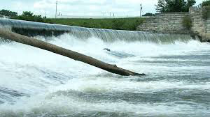
 In November, we mentioned that Marianne Cardwell and Jim Sparks were working with Data Science graduate students Taraka Srikrishna Kantipudi, Yamini Sri Vandana Penamakuru, Rajeni Nagarajan, and Sindhuja Madishetty on a national project to locate as many low-head dams as possible to improve the database inventory of these structures. The national project goal is to automate the detection process. Low-head dams are used to divert water from streams for agricultural and recreational purposes. They pose a danger to kayakers, rafters, and swimmers because the hydraulics during high water can swamp vessels and keep the swimmer pulled under at the base of the dam. The team looked at the feasibility of using orthoimagery data to detect the presence of those structures. The collaboration resulted in a 90% success rate in detecting the potential presence of a low head dam in the provided test images. Recommended future research includes achieving a way for the model to differentiate between low- and high-head dams and obtaining the location of the dams (latitude and longitude). The students presented their efforts in December to the Polis geoinformatics team and again to their class instructor and other students as their final capstone project. A representative from the Indiana Dept. of Homeland Security observed the presentation to the geoinformatics team and was impressed with the results. The project team will be sharing their results with others from Brigham Young University and Utah State University later this month.