
History of GIS in Indiana Part I: One Perspective
“I have worked with geographic information in one form or another since 1974 when I started as a rod man on a construction survey crew,” said Jim Sparks, Indiana Geographic Information Officer. “My first recollection of the use of the term “Geographic Information System” came from a panel presentation at a National Computer Graphics Association (founded in 1979 but now defunct) conference in 1982. I vividly recall my sense of relief to discover almost 50 other souls who were wrestling with the same kinds of “computer mapping” challenges that I was working through at the time. In contrast, I recently read that the attendance of the latest ESRI User Conference was over 15,000. How times have changed!
Fast forward to 1985: my career converged with Indiana GIS history when I accepted a project manager position at Mid States Engineering (more on MSE later). By the end of 1987, I was neck deep in managing a conversion project that would span 24 months and consume over 200,000 labor hours. The resulting Indianapolis Mapping and Infrastructure System (IMAGIS) won pioneering awards within the GIS and AM/FM (automated mapping and facilities management) communities, and rightly so.
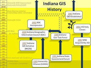 During the same period in Indiana, others in government, the private sector, and the university community were busy creating geographic information systems and geospatial data bases. These practitioners came together for the first time in 1990 for the inaugural statewide GIS conference organized by the University GIS Alliance (UGISA). Within a year of the conference, GIS users within state government formed the Indiana State Government Forum to share best practices and to foster an awareness of the activities that were occurring within INDOT, IDEM, DNR, and other state agencies. The forum later morphed into the Indiana Government GIS Task Force, and, with UGISA and representatives from the Federal government and the private sector, joined forces to form the Indiana Geographic Information Council (IGIC). IGIC, formerly the Indiana GIS Initiative, incorporated in 2002 as a 501(c)3 non-profit members organization, has been instrumental in creating a statewide vision and single voice for Indiana’s GIS, helping to facilitate critical geospatial projects, providing educational opportunities, and serving as a conduit for GIS news across Indiana. IGIC, along with the Indiana Government GIS Task Force, The Polis Center, and others, played a critical role in the passage of legislation that created the Indiana Geographic Information Office in 2007.
I have been asked many times how Indiana has been able to accomplish so much in the way of GIS, especially since we have never had an established recurring funding stream. The simple answer is that we all work very well with each other. Some of that comes from our Hoosier Hospitality mentality, and a lot of credit goes to IGIC, but I also believe that providence has contributed to our success by way of a highly successful, if unintended, Indiana GIS “technical school,” a.k.a. Mid States Engineering/MSE/ASI, Inc. In 1997, the year that MSE was acquired by ASI, over 400 GIS practitioners were employed at MSE in downtown Indianapolis. That office closed in 2002 and its 400 GIS professionals were forced to find other employment. The fortunate consequence of the demise of that office was that organizations across Indiana gained GIS resources who shared a common background, strong GIS skills, and a level of trust that was unique. That kinship has facilitated GIS cooperation in Indiana for a decade. It is not a stretch to say, as many have, that “you cannot swing a dead cat at any GIS meeting in Indiana without hitting a dozen ex-MSE’ers.” The alumni group includes the Executive Director of IGIC, the Program Manager of IMAGIS, the Director of Geoinformatics at The Polis Center, and the Indiana Geographic Information Officer (yours truly), to name a very few.
They rest is history, as the saying goes, but I recognize that this is only one of many perspectives of how GIS developed in Indiana. I therefore invite you to add your perception to this one so that together we can build a comprehensive History of GIS in Indiana.”
History of GIS in Indiana Part II: The MSE Perspective
“It’s interesting to think back to some of the accomplishments made by these 400+ GIS professionals who for a period of time all worked for Sol Miller, President of MSE,” said Phil Worrall, Executive Director of the Indiana Geographic Information Council. “I believe I bring a unique perspective to this history since I worked at Mid-States Engineering (and all its subsequent incarnations – MSE Corporation, MES-TEI, MSE-EIB, MSE-ids, MSE-ASI, and finally ASI) from 1975 to 2002. For almost 27 years my daily drive to work and my daily job of “making maps” hardly changed, but how I was doing that job transformed itself every few years into a whole new world – from hand drafting maps, to Automated Mapping (AM), to Automated Mapping and Facility Management (AM/FM), to Geographic Information System (GIS). Thanks to the vision of Sol Miller and his talented staff, we never had to look far for new challenges; they simply came to us as we all worked together to be the best at what we did. I dug up a few pictures to help us start down memory lane. Here is a picture of Sol Miller (on the left) in the MSE booth at the ~1994 AM/FM International Conference. I took this picture, and as I recall Sol is holding an award letter with Bill Muench and Barney Yoshioka from Hawaiian Electric that recognized their project with MSE as the top national AM/FM project for that year. It was not unusual for MSE clients to dominate annual awards like this.

From left: Sol Miller, Bill Muench, Barney Yoshioka
The first big “AM/FM” project at MSE began with IMAGIS base mapping and the subsequent mapping of the utility company overlays for Indianapolis Water, Gas, Sewer, and Electric systems. The problem is that you can only map your home town so many times, and early on it became clear that to feed and grow the MSE mapping machine we had to expand our client base not just outside Indianapolis or Indiana, but to the entire United States and internationally.
About the same time MSE became very successful working for the US Army Corps of Engineers making highly accurate photogrammetric maps and developing comprehensive AM/FM systems for US Army, Air Force, and Marine bases across the country and around the world. A military base is like a small city, with the entire infrastructure inside the fence managed by the military, so having detailed accurate digital maps became an important tool. These projects eventually led to MSE developing the standards, databases, conversion software, QA/QC tools, and utility modeling applications to be used by any engineering firm working at a military base belonging to the US Army and Air Force across Europe. Then the Berlin Wall came down, and everything changed again!
By then MSE had established a strong reputation in the utility industry for AM/FM records conversion, and through a strong partnership with the leading AM/FM consulting firm in the nation – UGC Consulting (owned by a former MSE employee – Glen Montgomery, with all his senior consulting staff graduates from the Indiana University School of Public and Environmental Affairs), the MSE mapping machine grew at a staggering pace.
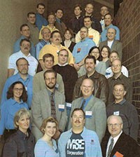
MSE Alumni at the 2006 IGIC Conference
At that time most new hires at MSE were new to mapping and to AM/FM/GIS, so most new hires had no experience and idea what they were getting into. It was not unusual during growth spurts for 20 new employees to start work as trainees on a Monday morning, and if they survived the first week of training they were assigned to a project and became temporary employees for the next 60 days. If they then survived this first 2 months they became full-time employees. It sounds crazy, but many did survive, and with the opportunity to learn and work with leading-edge technology and work on complex projects around the world, the cream rose quickly to the top, and many new careers in AM/FM/GIS were started and advanced quickly.
Just to prove that “you cannot swing a dead cat at any GIS meeting in Indiana without hitting a dozen ex-MSE’ers” is true, here is an impromptu MSE Alumni picture taken by Jim Sparks at the ~2006 IGIC Conference.
When I left in 2002 there were only six GIS staff left in the Indianapolis office of ASI, and all of these folks worked for ids (information delivery service – which by the way still exists today). Before heading for the door I took a few of my old MSE/ASI phone directory lists that had been taped onto my desk for the last 10 years. I scanned some of the pages for this blog, and you can see them here – https://www.igic.org/about/history/mse-phonelist.pdf
I’d love to see some posts from ex MSE’ers about where you are now and how your tenure at Indiana’s “GIS technical school” (as Jim calls it) impacted your career. My next post will be about the technology.
History of GIS in Indiana Part III: The Technology Perspective
“It’s interesting to look back at some of the technology that helped propel us from hand drawing maps to Automated Mapping and Facility Management, and then into the realm of GIS,” said Phil Worrall, Executive Director of the Indiana Geographic Information Council. “From an Indiana perspective the five big technology players that started the ball rolling were:
- Computervision
- Synercom Technologies (Informap)
- M&S Computing (Intergraph IGDS/DMRS)
- Bentley Systems (MicroStation)
- Graphic Data Systems (GDS)
Today, Esri’s ArcGIS and WTH ThinkMap dominate the GIS user community across Indiana. It will be interesting to see what we are using 10 years from now.
Back in 1978-1979, at Mid-States Engineering, we were looking for a way to automate our photogrammetric map production. At that time all maps were drawn by hand, but we did have one electronic drafting table attached to the stereoplotter I worked on. It was fairly efficient (when it worked), but the output was still a physical map, and we wanted a system that would store the map on a hard drive and display it on a monitor to edit and then plot.
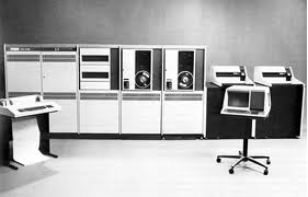
 There were only three viable alternatives: Computervision, Synercom Technologies, and M&S Computing. All ran on Digital Equipment Corporation PDP/VAX Computers, and each company built custom graphics workstations to attach to the computer. At the time, only two of these companies, Synercom and M&S, were interested in breaking into the photogrammetric mapping market.
The competition was stiff, but Mid-States eventually selected Synercom because the science behind its photogrammetric solution was developed by well known Swiss surveying instrument firm Wild Heerbrugg. And as they say, the rest is history. Synercom was subsequently selected for the IMAGIS base mapping project, and then by the Indianapolis Sewer, Gas, Water, Electric, and Telephone utilities.
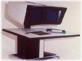
The graphic workstations were dumb-terminals with large graphic displays and a digitizing table to capture data from paper maps. All the computing power was in the PDP/VAX computer, and at the time our VAX had a total of 1MB of RAM. I do not remember who, but someone started calling the workstations “boat anchors.”
Meanwhile Graphic Data Systems (GDS) became the CAD/GIS system of choice for the Indiana Department of Transportation. And in a past life, our State GIO Jim Sparks managed that system for INDOT.
 Looking back, from a functionality and design standpoint, both the Synercom and GDS systems were way ahead of their time, and should have dominated the market, but marketing was not one of either companies’ strengths, and eventually M&S Computing (rebranded as Intergraph Corporation, Huntsville AL) became the technology leader in the Automated Mapping/Facility Management (AM/FM) and CAD markets, and ESRI established a name for itself in the emerging GIS market. At MSE we purchased our first of four Intergraph PDP/VAX system in 1982.
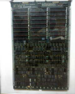
One way Intergraph excelled was by developing a custom graphics card to plug into the CPU thereby providing faster workstation display/refresh rates. The graphics card plugged directly into the bus on the VAX computer (about 2 ‘ x 3’ in size) and provided an additional 1 MB of dedicated memory to support the display of map data on the workstations. Just take a look at all the rows of 8K memory chips mounted on the top half of the card.
Oh, and if anyone would like to see it in person, it’s stored in my basement.
It was still really expensive to buy additional workstations at around $50k each, so in 1985, two brothers from Pennsylvania, Keith and Barry Bentley, introduced PseudoStation. MSE immediately purchased a number of copies because it allowed us to add low-cost graphics terminals to view and modify the designs on our Intergraph System.
In 1986 the Bentley brothers followed PseudoStation with a stand-alone personal computer-based CAD system compatible with the Intergraph CAD file format called MicroStation. At that time MSE went out and purchased the latest/greatest Compaq 386 – 16 Mhz PCs to run MicroStation Version 1.1. Within three years MSE had over 100 standalone UNIX workstations and PCs running MicroStation, and virtually all of the VAX technology was being retired.
Another way Intergraph excelled was to purchase a controlling interest in Bentley and migrate quickly toward a standalone workstation/PC platform. INDOT also migrated much of their CAD work to MicroStation, and in 1999 the State of Indiana selected ESRI to replace GDS. As you can see from the picture some creative folks eventually found a good use for the old Intergraph “boat anchor” workstations.
 At MSE we found out immediately that we could not use any of these commercial off-the-shelf CAD and GIS software packages effectively for data conversion. Even custom applications developed by the software companies for Telephone Outside Plant, Electric Networks and other utilities were not productive in a mass data conversion environment. Additionally, we could not afford to license and/or retrain our production staff in the latest flavor of GIS our clients used. At any point in time we could be working on projects for final delivery in Informap, MicroStation, GenaMap, GDS, ArcInfo, Framme, Smallworld, AutoCAD, and other formats.
As a result, we spent significant time and money at MSE developing our own in-house conversion software. Our first versions were based on Intergraph and then MicroStation written by some of our talented digitizing technicians “Dig Dogs” turned into “User Command Programmers,” but later evolved to our own home grown GIS platform, called GNOME, written by a staff of talented software engineers who could not even spell “GIS” the first day they started work at MSE. I can no longer remember what the “GNOME” acronym stands for, but someone out there will – it was real cool stuff!”