
 The Polis Geoinformatics department is creating Building Footprints for the state from LiDAR. Marianne Cardwell created a building outline layer for the Indiana Department of Natural Resources (IDNR) earlier this year to help determine the risk of flooding on a structure level. At the beginning of June, FEMA authorized the distribution of this building layer to other agencies within the state, especially the GIO. Marianne and Dave Knipe (IDNR) will present this work to the Indiana Silver Jackets at its July 15 meeting.
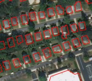
The Geoinformatics team also continues working with Prof. Chakraborty (Assistant Professor, Data Science, IU School of Informatics and Computing-IUPUI) and a graduate student Priyanka Surapaneni to investigate the use of machine and deep learning to identify the use of buildings. Currently, the team is trying to perform some simple classification of buildings, such as agricultural, commercial, and residential, with the aim of classifying the buildings into sub-categories. In addition, the U.S. Army Corps. of Engineers (USACE) approved an Interagency Nonstructural Flood Risk Management grant to verify the accuracy of and augment the building footprints.
The project kick-off meeting was June 24 and included participants from U.S. Army Corps of Engineers (USACE) – Louisville District, IDNR, and the Indiana Department of Homeland Security (IDHS). Polis, IDNR, and IDHS do not receive funds for this project, but will provide subject matter expertise to the Corps.